Showing posts with label weather. Show all posts

Tuesday, April 9, 2013

Wild Weather in Kandahar


We had a bout of violent thunderstorms tear through Kandahar. Our offices were pummeled by high winds and torrential rain for about an hour today.  It was a strong storm and when we made our way back from the office park to the residential camp a mile away, we saw how strong it really was. 
A work yard just near our residential camp was hit by a microburst as every structure in the work yard was flattened.  This was a work yard that was about 100 yards wide and about 300 yards long.  No structure survived and the perimeter fence was down with some of the trees in this area snapped in two like twigs. Our residential camp was OK but the large antenna mast that holds our internet dish was knocked down.
We have lost our main internet connection and are limited to net connectivity at our office for the newt few days. 
The weather here can be powerful when it wants to and this was one of those times.  When a storm comes across the open desert, there is little to slow it down or stop it.

The last three days of wild weather ended with a brilliant sunset on Tuesday evening.  It was nice to see and standing there admiring God's handiwork while smoking a cigar was the perfect way to end the day.


Friday, October 26, 2012

Hurricane Sandy heading to East Coast as " Frankenstorm"

A late season storm will look to make a mess of things over the next week.  This is almost a carbon copy of what was called " The Perfect Storm " that happened in October 1991. Due to it arriving at Halloween, they have dubbed it " Frankenstorm " based on that it is a mix of winter cooler air and the subtropical storm coming from the south.


No matter where this makes landfall, this storm will make a mess of things for the East Coast.
 
Hybrid of Sandy, winter storm threatens East Coast
 
WASHINGTON (AP) — Government forecasters say a big storm that they're calling "Frankenstorm" is likely to blast most of the U.S. East Coast next week.
 
The storm is an unusual mix of a hurricane and a winter storm. The worst of it could be focused around New York City and New Jersey.
 
Forecasters on Thursday said there's a 90 percent chance that the East will get steady gale-force winds, flooding, heavy rain and maybe snow starting Sunday and stretching past Wednesday.

The hurricane part of the storm is likely to come ashore somewhere in New Jersey on Tuesday morning.

NOAA forecaster Jim Cisco said the storm is so massive that the effects will be felt along the entire coast from Florida to Maine and inland to Ohio.

Monday, August 13, 2012

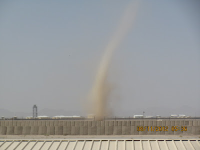
Dust Devils in Kandahar

I have been reading about the drought that is hitting most of the good old USA - Luckily, the New England area has no issue with rain as back home, they have been getting a serious soaking.... I feel sorry for the farmers and others suffering under this seasonal stretch of dryness......

Here in Kandahar, it is HOT, Dry and Dusty....Oh yeah, did I mention DUSTY ??

Here are a few shots of what I am talking about.....Some serious Dust Devils tearing up the sands....


Sunday, July 29, 2012

Local Weather Forecast in Boston.....Looks legit....

Being overseas in Afghanistan and away from home in the Boston area, I check in on the news & weather back home to see how things are back home.....When I logged on to the WBZ Weather page, it appears that "Global Warming" is really not happening in Boston -

Here is what the forecast was for Sunday 29 July 2012


Here is the link - http://weather.boston.cbslocal.com/US/MA/Boston/KBOS.html

I think if it gets down to " 4 " degrees tonight, a large number of locals will be caught by surprise.  It is likely they corrected their error by now but looking at the weather forecast they posted, it seems likely that the WBZ weather crew had quite a large number of beers last night.

Saturday, October 29, 2011

Let the games begin....Boston area will get its first real taste of winter

Mother Nature is not playing fair. We here in the New England area will be treated to the first real snow of the winter and the weathermen are hyping it as usual.

Luckily, those of us who live in SE Massachusetts will see more of a slush mix but the residents of Massachusetts & NH who are west & north of Boston could be in for the real deal. On top of that, the trees are still holding their fall colors which means many could find tree limbs taking out power lines....that is not something you want to hear this early into the fall.

We will see what Sunday holds for all here and hopefully it won't be a major headache. This is not what most want to see at the end of October.

State could see up to foot of snow
By Martin Finucane, Jaime Lutz and Amanda Cedrone
Globe Staff Globe Correspondents / October 29, 2011

A rare October snowstorm could dump up to a foot of snow today in western parts of the state and in Central Massachusetts toward the New Hampshire border, the National Weather Service warned yesterday.

Two to 6 inches of snow are expected closer to the coast, the weather service said.

In addition to weighing down tree limbs and power lines with heavy, wet snow, the storm will also rake the state with strong winds and pound the coast with moderate flooding, forecasters warned.

Communities as close to Boston as Stow and Littleton could get up to 6 inches. Boston itself could get 1 to 3 inches. Weather officials have the “lowest confidence’’ in forecasting the precipitation in the Boston area, however, as today’s temperatures are crucial in determining the amount of snow.

The Boston area will start seeing cold rain at about 4 p.m. today, but it is not expected to change to snow until about midnight, said Joe Dellicarpini, a Weather Service meteorologist. Early risers may see snowflakes tomorrow morning, as snowfall is expected through about 8 a.m.

Snow is expected to form in the afternoon in higher interior areas of Central and Western Massachusetts between 2 p.m. and 4 p.m., with the heaviest snowfall expected just in time for dinner. The snow should be clear of the area at about 5 a.m. tomorrow.

Forecasters say this storm has potential to be a record-breaker. The biggest October snow ever recorded in Boston was 1.1 inches on Oct. 29, 2005. The biggest October snow in Worcester was 7.5 inches on Oct. 10, 1979, the weather service said.

In Eastern Massachusetts, the snow will be teamed with strong winds, forecasters said. They issued a warning of winds gusting between 45 and 55 miles per hour in and around Boston. On the Cape and islands, gusts could reach 60 miles per hour.

After the storm moves out early tomorrow, conditions will be dry, and Boston will see increasing sunshine. Temperatures will reach the low to mid-40s.

Halloween will be similar to yesterday: sunny and cold. Temperatures will reach around 50. Each day after that, said meteorologist Bill Simpson, there will be a gradual warming trend through Thursday.

Officials around the state are preparing for the snow.

“All of our district highway directors are preparing their staff,’’ said Cyndi Roy, spokeswoman for the state Department of Transportation. “The staff is inspecting equipment to make sure it’s ready to go.’’

The DOT has also enlisted contractors to help out with the salting, sanding, and plowing.

She added that the MBTA and Massport both have plans ready for the snow and ice.

National Grid is preparing for potential outages, with crews scheduled to work, and additional contract crews reserved if response is needed to hard-hit areas, according to spokeswoman Debbie Drew. NStar will be activating an emergency response plan this afternoon, said Mike Durand, a spokesman.

The company will open regional service centers as storm response headquarters, add extra line crews and support staff, and also add staff to the customer call center, he said.

Globe correspondent Taylor M. Miles contributed to this report.

Sunday, August 28, 2011

Hurricane Irene arrives or is it Hype-icane Irene

Hurricane Irene arrived this morning to New England with more HYPE than anything else. Like most cases of weather in New England, they build up the storm to biblical proportions, and then it arrives with a "thud" of all hype and no storm.

Southern areas were hit harder and the storm has caused 10 deaths to date. Many were storm related like one man who dies when his home caught fire due to wind related downed powerlines.
I would rather have the storm be a dud as that way no one gets hurt and there is no damage to homes and such but the media shouldn't play this up like it will be the "Storm of the Century" when they likely know it will be just another basic storm by the time it hits ther greater New England area.

We reguarly get 30-50 mph winds here with coastal storms so the weather bears watching but this storm was a bigger issue for those down south than here in southern Massachusetts.

Get Real: Hurricane Irene Should Be Renamed "Hurricane Hype"
Forbes.com OP-ED

Over the years the National Hurricane Center (NHC) has employed the world’s best experts on Atlantic tropical cyclones, from “Dr. Bob” Simpson, to the mediagenic Neil Frank and on to the current director, Bill Read.

The lifesaver-in-chief was probably Frank, who indefatigably crisscrossed the nation educating the public to the dangers—hidden and obvious—that accompany these curiously seductive weather systems. His era was one of many innovations, including extensive use of satellites, and tailoring the “names” of storms to the culture where they roam in order to attract attention.

One of Frank’s nightmare scenarios goes like this: A strong hurricane threatens a heavily-populated resort area with few escape routes, such as the North Carolina Outer Banks. Vacationers reluctantly abandon their $20,000/week palaces on Pine Island for 36 hours in an immobile SUV conga line, drenching tropical showers, and no toilets. The storm falls apart or unexpectedly turns away from land. Lotsa folks rent for more than a week, so they return, an equally strong storm shows up, and they don’t leave. The title of this movie is “how to die in a 10,000 square foot house-boat”.

We have just lived through something pretty close to this nightmare. Last April 27, in Tuscaloosa, Alabama, 41 died because they disregarded a weather warning.

While the number of strong tornadoes is hardly changing (there may even be a slight decline), the number of tornado warnings has increased exponentially as Doppler radar picks up twisting circulations embedded in thunderstorms that could produce a ground tornado.

The number of false positives has so cheapened the currency of tornado warnings that few now bother to interrupt their work when one is given. While the very good forecasters at the National Weather Service were not at all happy when veteran TV meteorologist James Spann blamed a large number of Tuscaloosa deaths on the very high false alarm rates, he had a point.

Now on to Hurricane Irene:

Up until now (Friday evening) Irene has been very similar to 1985 hurricane Gloria, though a bit weaker. But the level of hype—because of its projected path near all of the I-95 major cities—is similar to that of 26 years ago.

When Gloria proved less deadly than expected CBS’s Dan Rather—a serial hurricane hyper who made his career on 1961 Hurricane Carla—he yelled at poor Neil Frank on live TV

What had happened is that the night before landfall, Gloria took a sudden 40-mile jog to the east. The cyclone slid harmlessly east of the big cities, showing her weaker western side instead of the destructive northeast corner.

Irene has put on a remarkably similar show. Within the limits of forecasting error, Irene’s projected path makes it was impossible to rule out a major disaster. But, as a dangerous Category 3 storm within two days of land, something similar to what happened to Gloria occurred. Instead of going slightly off course, the power of her winds dropped markedly, at least as measured by hurricane hunter aircraft. Because it is prudent to not respond to every little tropical cyclone twitch (such as Gloria’s jog or Thursday’s wind drop), the Thursday evening forecast was virtually unchanged, the Internet went thermonuclear, and the Weather Channel’s advertising rates skyrocketed. From that point on, it became all Irene, all the time. With this level of noise, the political process has to respond with full mobilization. Hype begets hype.

A day later, the smart money is still riding a very Gloria-like track, but with a cyclone that will be weaker than projected (and hopefully kill fewer than the eight people who died in Gloria) though power outages east of where the center makes landfall (probably on Long Island) may be extensive.

As I complete this, there’s another tropical depression out in the Atlantic, and a couple more on the way in the very near future. Suppose one of these takes a similar path, except that it improbably threads the needle of the Mid-Atlantic Bight and makes landfall immediately to the west of New York City as a Category 3 storm. How many people will the hyping of Irene have killed?

That’s how Hurricane Hype followed by Hurricane Insanity leads to hurricane death.

I see a solution, in all places, in Washington DC, where a group of crackerjack weather forecasters, led Jason Samenow, have set up the Capital Weather Gang (www.capitalweathergang.com). It’s become the go-to group for potentially severe winter storms here (including hurricanes), and, because they are serving a smaller community than, say, NHC, they aren’t under the massive scrutiny of a politicized media. Is it time for similar diversity to develop all over the high-stakes world of tropical cyclones?

Or would that be an abject disaster? Consider if there are five competing hurricane forecasters, four suggesting evacuation while the fifth says “stay put”, and the fifth one is wrong. Surely most people would choose to stay, with disastrous results. Given the nature of the Internet, such an experiment is sure to run in the near future